
Cherokee Ridge Alpine Trail

The Cherokee Ridge Trail is one of the latest outdoor activity additions to the River Region. Dedicated April 30, 2004, by the Cherokee Ridge Alpine Trail Association, it is located about 1.5 miles from Lake Martin Dam. The trailhead is located at the Scenic Overlook just east of Lake Martin Dam and is divided into smaller trails of varying lengths and difficulties:
- Cherokee Ridge Alpine Trail – 4 mile loop
- Chimney Rock Trail – 2 mile loop off the Cherokee Ridge Alpine Trail
- The Kowaliga Bay Trail - 1 mile loop
- Deadening Alpine Trail – 3 mile route said to be scenic but difficult and will traverse along a part of Lake Martin made up of the old Tallapoosa River Gorge
- Wind Creek Cherokee Bluff Trail – 8 mile planned future trail
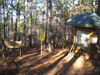 The trails are built on Alabama Power Company land that is set aside as “natural undeveloped” and provide excellent views of the Kowaliga Bay.
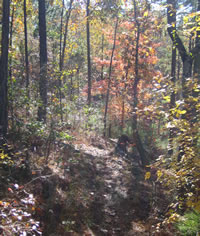
The trails wind throughout the wooded area and ascents/descents are generally gradual, but there are a few tricky spots along the routes.
The trails are open to foot traffic only – no bicycles, motorbikes or pack animals
The trailhead can be reached from State Highway 50 via Overlook Drive.
 From the East (Walnut Hill) go west on Highway 50 and turn right on Overlook Drive, which is marked by a Scenic Overlook sign. The trailhead parking lot is 3.3 miles on the right.
From the West (Red Hill) go east on Highway 50 and turn left onto Overlook Drive at the Martin Dam sign .3 mile after crossing over the Tallapoosa River. Follow the newly built road to the trailhead parking lot that is 1.5 miles on the left.
**More Picutures from the Cherokee Ridge Alpine Trail**
Additional websites relating to the trail:
Cherokee Ridge Alpine Trail Website

 |